


Space-Borne Flood Modeling
Improved Land Surface Application Of Current and Future Hydrologic Remote Sensing Missions
In this research, we explore ways to improve application of current and planned hydrologic remote sensing space missions for understanding and modeling of land surface processes. Two specific applications are targeted for this purpose: (1) Flood Forecasting over un-gauged basins and International River Basins; (2) The Land Information System (LIS) of NASA-GSFC that has multi-dimensional societal applications. The future missions that we try to assess are: (1) Global Precipitation Measurement (GPM, Figure 1) mission and (2) Hydrospheric State (HYDROS, Figure 2) mission; while for current missions our study is limited to the existing constellation of passive microwave (PM) and infra-red (IR) sensors.
We are concerned mainly with two specific hydrologic measurements: precipitation (from PM, IR sensors and GPM) and soil moisture (expected from HYDROS). Precipitation is arguably the most important component of the land-atmospheric system accountable for shaping the climatic state and variability of water in the soil and atmosphere. Understanding the fate of precipitation as soil moisture, evapo-transpiration and runoff is the key to capturing the global make-up of surface hydrology. Soil moisture on the other hand controls the feedback and interactions between the land surface and atmospheric processes. Knowledge of soil moisture is critical for understanding the partitioning of rainfall to runoff and infiltration (for flood forecasting purposes) and initialization of numerical weather prediction models to produce skillful forecast. Thus due to the cost-effectiveness and anticipated large scale availability of space-borne remote sensing measurements, we now realise that a global assessment of the surface hydrologic processes is possible only through missions such as GPM and HYDROS, at least for the forseeable future.
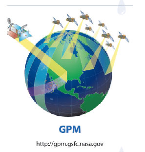
Figure 1. The anticipated Global Precipitation Measurement (GPM) mission
(Source: http://gpm.gsfc.nasa.gov)
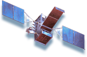
Figure 2. The anticipated HYDROS mission for soil moisture measurement
(Source: http://hydros.gsfc.nasa.gov)
Our fundamental question of concern in this research area is “How can we make better predictions of the land surface state (such as soil moisture and runoff) in future than what we are capable of today?” We attempt to answer this question by first making a very thorough understanding of the uncertainty in the remote sensing measurement. This understanding has currently been achieved through the development of a Two Dimensional Satellite Rainfall Error Model (SREM2D). Unlike radar rainfall estimation, where after careful quality control and error adjustments the residual error is left with primarily a random deviation component (sometimes of low spatio-temporal correlation), the satellite rain retrieval uncertainty is associated with correlated rain/no-rain detection and false alarm error characteristics as well as systematic and random rain rate error components with longer spatio-temporal correlation lengths. The desired progression to finer scales (space-time) in satellite remote sensing that is needed for more accurate simulations is actually counter-balanced by the increasing multi-dimensionality of the measurement error. Recently, our studies have shown that SREM2D has 70% greater accuracy in capturing the precipitation error structure than conventional modeling techniques. Subsequently, we model the manifestation of precipitation uncertainty in the simulated surface hydrologic variable by coupling SREM2D with land surface models. This allows a definitive understanding of the hydrologic implications of remote sensing input uncertainty. Our research method also offers a framework for providing focused feedback to the precipitation remote sensing community for development of next generation multi-sensor algorithms. In the past, feedback has been negligible between precipitation remote sensing and its hydrologic application and research activity concerning one area usually evolved independently of the other.
Two particular aspects of our research that may prove successful in the long-run in serving large scale societal needs are that of (1) Flood forecasting in International River Basins (Figure 3a) and a (2) Fully space-borne early warning systems for floods over un-gauged tropical regions of the developing world by combining HYDROS with GPM and the now discussed stream-flow mission called HYDRASAT (Figure 3b). For such regions, satellite rainfall from passive sensors is the only available rainfall input source with the potential for serving large-scale societal needs. A situation that is often overlooked in this regard is that several countries have most (more than 95%) of their territory within one or more international river basins, thus forced to cope with flooding primarily generated beyond their borders (e.g., the Bangladesh delta in the Ganges, Brahmaputra and Meghna river basins-Figure 3c). The vantage of meteorological satellites in space provides a way of monitoring rainfall across political boundaries or un-gauged terrain, which appears a plausible alternative for enhancing the flood forecasting capability of many flood prone lowermost riparian nations (such as Bangladesh).More details on these two research activities may be found in our list of recent publications.
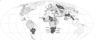
Figure 3a. Map of International River Basins [Courtesy of Dr. Aaron Wolf, Transboundary Freshwater Dispute Database – Oregon State University]
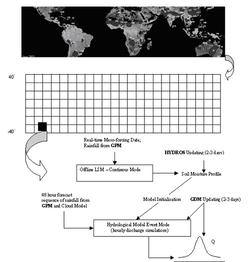
Figure 3b. A proposed framework for early warning of floods from a fully space-borne system.
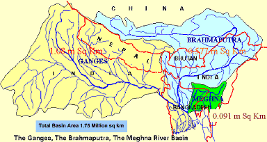
Figure 3c. Ganges Brahmaputra Meghna Basin (GBM) – an example of an International River
Basin where the flood forecasting range of the lowermost riparian nation is limited due to
unavailable rainfall from upstream nations.
Presentation: The Challenges of Flood Monitoring Across Political Boundaries: Taking Stock of Emerging Opportunities and Moving Ahead.
Powerpoint Presentation Word Abstract
Funding Agencies; NASA, NSF, USAID